Posts

Showing posts with the label Chickahominy River

Catherine Barrett of Early James City County

Image
Catherine Barrett of early James City County has been a perplexing individual to research. Some of the confusion has to do with very early assumed familial connections for her which have been accepted without documentation. So, if you've found yourself looking at the evidence pertaining to Catherine Barrett's life, you too have probably wondered when looking at various online lineages,  "How do they know for sure that was Catherine Barrett?"   Let's look at what we do know of her early life in James City County, Virginia.  What We Can Document 1713 Catherine Barrett's debut into the world of records was on November 13, 1713 when Simon Jeffreys received a 167 acre land patent. Jeffreys acreage was described in the patent as being on the west side of the Chickahominy River in the parish of Wilmington, James City County . Water courses that bounded Jeffreys' acreage included Webbs Run and Tobacco House Run. Adjacent landowners were Thomas Rogers and Catherin...

The Anderson Goldmine Creek Property

Image
The Anderson Land Patent for Goldmine The Andersons are one of those prolific families of which you'll find connections to in just about every other family in early Hanover County. They also owned land all over Hanover County, within both St. Paul's and St. Martin's Parishes. One particular location in which they lived, and are probably most known for, is the Anderson plantation located at Goldmine Creek. In fact, back in 1913 Edward Lowell Anderson published a book entitled The Andersons of Gold Mine, Hanover County, Virginia. Interestingly, Edward Lowell Anderson stated in his book that he was unable to find the origin of the land. But an expanded inspection of one particular Anderson land patent gives the location away. The land for the Goldmine plantation appears to have been issued in a 1723 land patent of 400 acres granted to Robert Anderson of Hanover County and Charles Anderson of King William County for the sum of 40 shillings, The patent can be viewed on the  Li...

Mr. John White's Beaverdam Creek Land 1711 to 1784

Image
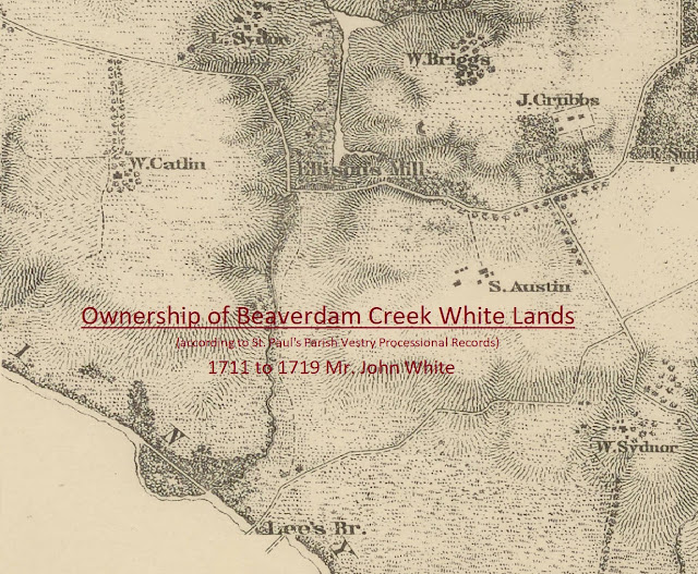
In an earlier post , we found that Mr. John White owned two pieces of land, 320 and 190 acres, according to the 1704 New Kent County Quit Rent roll.  And yet, there is no known record of how he obtained these properties.  The first known record of Mr. John White obtaining land was a 1705 land patent for 211 acres in New Kent County, on the east side of Beaverdam Creek.  It is probable that these 211 acres were across the creek from one of his other tracts (320 or 190 acres) that included the White Mill.  The only known existing records to track the ownership of Mr. John White's properties at Beaverdam Creek are the precinct processions of the St. Paul's Parish Vestry Record .  Although the precinct numbers changed over time, the surrounding land owners of Mr. John White's Beaverdam property stayed the same, allowing us to follow ownership changes .     Below is a visual chronology of the procession years and the responsible parties for the Beaverdam...

What Happened to Mr. John White's Lands?

Image
In the previous post , the general locations of Mr. John White's four different tracts of land in St. Paul's Parish were identified.  Each tract was located in a distinctly different location within the parish.  So, what happened to these lands? 1731 Based upon the St. Paul's Parish Vestry Record, Mr. John White conveyed two of these tracts of land sometime between 1719 and 1731 to John White Jr. and Samuel White.  Unfortunately, there are no extant parish procession records or deeds between 1719 and 1731, so the actual year of these transactions cannot be confirmed.  But we do know that by 1731, John White Jr. was in possession of the land surrounding Beaverdam Creek in the Green Community, a nd Samuel White became the owner of the land in the Blue Community .  An analysis of what happened to John White Jr.'s land and Samuel White's land will be outlined in a future post. After Mr. John White transferred his lands in the Green and Blue Communities to...

Mr. John White's Lands near Beaverdam Creek and Chickahominy River - Green Community

Image
The early Green Community property owners included John White, Edward Clark, Charles Fleming, Capt. Nathaniel West, Thomas Massey/Massie, Thomas Bailey, Richard Melton, and William Macon (son of Mr. Gideon Macon).   When we check the 1708/09 St. Paul's Parish processioning records, these names are conspicuously missing.  However, the 1708/09 processional record is missing entries for precincts 31 and 32.  It is very likely that the Green Community comprised one of these missing precincts.  By analyzing the 1711 to 1719 procession records in the below chart, the Green and Yellow communities were consistently listed as precincts 18 and 19 implying that they were near one another, if not adjacent.  Since the Yellow community in 1708/09 made up Precinct 33, it is very likely that the Green community was either precinct 31 or 32.   Procession Years and Precincts for Mr. John White's Lands Locating the Green Community The primary key to locating th...

Mr. John White Records 1695 to 1705

Image
1695 to 1705 Record Analysis for John White 1695 Court Order to Maintain Roadways The 1695 New Kent County Court order for Mr. John White is an excellent record.   It provides an honorific name to follow, as well as a specific geographical region within New Kent County.   More importantly, the time span from 1695 (original court order) to 1705 (confirmation of the court order) shows that Mr. John White had an interest in this geographical area for at least ten years.   Figure 1 illustrates an approximate boundary of the court order described area.   The boundary was drawn on an 1867 map of Hanover County r etrieved from the Library of Congress .  Figure 1 A  Represents the mouth of Elder Swamp at Chickahominy River B  Represents the unknown Little Creek, branch of Matadequin Creek C  Represents the approximate area for Pole Green Quarter D  Represents the mouth of Beaverdam Creek at Chickahominy River This geogr...