Posts

Showing posts with the label Matadequin Creek

Namesake for William Reynolds Burnett?

Image
While researching the Burnetts of Hanover County, Virginia, the name William Reynolds Burnett came up repeatedly.  Apparently, William took his middle name of "Reynolds" very seriously as he is referred to in full Christian name in many early records.  The first entry of his full name is in the 1739 St. Paul's Parish procession record for Precinct 19.  In the same precinct, Abraham Burnett was also listed but with no middle name or initial.  In fact, most of the Burnetts in the extant Hanover County, Virginia records were recorded with only a first and last name.  Occasionally, a middle initial would be used to differentiate Burnett men with the same first name.  But rarely was the full middle name used with such emphasis; William Reynolds Burnett.  Below is an example of Burnett's full name copied from the 1763 Hanover County Quit Rent Roll (transcribed) showing that he paid his land tax for 100 acres to the King of England. Each time I came acro...
A Town & Country Relationship

Image
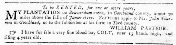
A few years back, I came across the below 1778 Virginia Gazette advertisement while researching my Thurman family.  This Revolutionary War era ad created more questions for me than answers.  I couldn't help but wonder why "Mr. John Thurman", a young man originally from rural Hanover County, was acting on behalf of Dr. William Pasteur , the eminent 18th century Williamsburg surgeon and apothecary.  Pasteur's Beaverdam Creek plantation, mentioned in the ad, was comprised of 700 acres on the north side of the James River.  Today, there is a historic home known as Mount Bernard which proudly stands on a small portion of the original plantation which maintains sweeping views of the James River valley.  According to a historic survey of the property prepared by the Virginia Department of Historic Resources , it is believed that Mount Bernard was built upon an 18th century foundation - the time frame of the below subject ad.    1778 Virginia Gazette...

Serendipitous Land Research

Image
White is not the only Hanover County surname that I research.  And sometimes, researching multiple surnames can lead to unexpected surprises.  Such was the case while researching my Wade family connection with friend and fellow researcher Sydni Thurmond-Hamill. Sydni has a very lively and well connected Instagram presence.     A great passion of hers is to follow historic architecture and landscapes.  One of her favorite Instagram architectural historians is Gray O'Dell  who one day posted a photo of Quietude , a historic home in Hanover County off McClellan Road.  In the post, O'Dell mentioned Edmond Wade/Waid (herein after Wade) and his possible lineage.  Knowing of my Wade family interest, Sydni excitedly texted me and we were off and running in trying to determine Edmond Wade's ancestors by taking the "follow the land" approach. Sydni began identifying Wade properties that were labeled on various Civil War era maps. Using these old ma...

What Happened to Mr. John White's Lands?

Image
In the previous post , the general locations of Mr. John White's four different tracts of land in St. Paul's Parish were identified.  Each tract was located in a distinctly different location within the parish.  So, what happened to these lands? 1731 Based upon the St. Paul's Parish Vestry Record, Mr. John White conveyed two of these tracts of land sometime between 1719 and 1731 to John White Jr. and Samuel White.  Unfortunately, there are no extant parish procession records or deeds between 1719 and 1731, so the actual year of these transactions cannot be confirmed.  But we do know that by 1731, John White Jr. was in possession of the land surrounding Beaverdam Creek in the Green Community, a nd Samuel White became the owner of the land in the Blue Community .  An analysis of what happened to John White Jr.'s land and Samuel White's land will be outlined in a future post. After Mr. John White transferred his lands in the Green and Blue Communities to...