Posts

Showing posts with the label New Kent County

Father of John, Joseph, Nicholas, and Thomas Holt

Image
What was the relationship between John and Joseph Holt who married sisters Helena Maria and Edith White? Three Louisa County deeds help to steer us to the answer.  The three deeds include: July 8, 1758 Louisa County VA DB B page 333-334 Joseph Holt of New Kent County and Joseph Holt Jr. of Louisa County VA ..."give a negro girl named Fanny and all her increase"...witnessed by John Holt and Elisha White  (The witnesses to this deed tell us that the Joseph Holt we've been following in Louisa County is also known as Joseph Holt Jr. The question is, who was Joseph Holt of New Kent County?)  September 25, 1759 Louisa County VA DB B page 333-334 Joseph Holt Sr. of New Kent County and Nicholas Holt of Charles City Co ., "for love and affection... 400 acres in Louisa County on both sides of Treasurer’s Run" (Joseph Holt Sr. appears to be the same Joseph Holt of New Kent County in the previous deed. But who was Nicholas Holt?)   March 26, 1762 Louisa County VA DB C ...

John Barnet or John Burnet?

Image
FamilySearch.com never ceases to amaze me! Today, from the comfort of my own home, I came across the original pages that were transcribed by C. G. Chamberlayne for his publication  Vestry Book of  St. Paul's Parish Hanover County Virginia 1706-1786 ! Thank you FamilySearch.com! In a previous entry, I noted how many Burnett researchers have ignored Chamberlayne's transcription of Precinct 27 in 1708. In his transcription, Chamberlayne listed a John BARNET and an Edwd BURNET within the same precinct. Unfortunately, Chamberlayne's meticulous transcription effort has been ignored for this precinct and some Burnett researchers decided that a transcription mistake was made and that the transcription for "John BARNET" should have read, "John BURNET". So, let's take a look at the full original page! And here's a cropped version. Without a doubt, the original entry is "John BARNET" who was listed as an interested landowner in the 1708 entry and ...

John Burnett of New Kent County, Virginia

Image
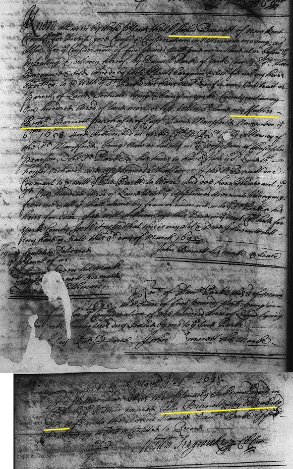
Why do so many Burnett family researchers focus on connecting John Burnett of New Kent County, son of Richard Burnett of York County, to the St. Paul's Parish, Hanover County Burnetts?   The claim is that John Burnett, son of Richard Burnett and husband of Elizabeth, was living in Blisland Parish, New Kent County and then moved to St. Paul's Parish where he allegedly died about 1706.  As a focused Hanover County researcher, I've found no evidence of John Burnett of New Kent County having lived or died in St. Paul's Parish.  However, there is substantial evidence of a John Burnett and an Elizabeth Burnett that lived in Blisland Parish well into the year 1756.  Perhaps a fresh look at the records needs to be taken. 1695 - John and Elizabeth Burnett of New Kent County, Virginia The record of interest is the below 1695 York County deed involving John Burnett of New Kent County and Daniel Parke Esq. of York County (it is not clear at this time if this was the grandfa...

Namesake for William Reynolds Burnett?

Image
While researching the Burnetts of Hanover County, Virginia, the name William Reynolds Burnett came up repeatedly.  Apparently, William took his middle name of "Reynolds" very seriously as he is referred to in full Christian name in many early records.  The first entry of his full name is in the 1739 St. Paul's Parish procession record for Precinct 19.  In the same precinct, Abraham Burnett was also listed but with no middle name or initial.  In fact, most of the Burnetts in the extant Hanover County, Virginia records were recorded with only a first and last name.  Occasionally, a middle initial would be used to differentiate Burnett men with the same first name.  But rarely was the full middle name used with such emphasis; William Reynolds Burnett.  Below is an example of Burnett's full name copied from the 1763 Hanover County Quit Rent Roll (transcribed) showing that he paid his land tax for 100 acres to the King of England. Each time I came acro...

Mr. John White's Land in St. Paul's Parish (Yellow Community) - Cold Harbor Neighbors James Garrett and Thomas Hooper

Image
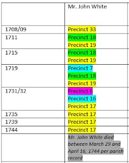
Since we now know the Green Community was located along the Chickahominy River loosely bounded by Beaverdam and Powhite Creeks, we should be able to find the general location of the Yellow Community.   If we look at the below table which shows the St. Paul's Parish procession precinct information for Mr. John White's lands, we can see from the precinct numbering pattern from 1711 to 1719, that the Green and Yellow Communities were adjacent or very near to one another.  And since there is no known record for how Mr. John White obtained land in the Green Community or a description of the land, the key to narrowing in on a more specific location is the available property information for the other landowners listed in the precinct processions. Neighboring  Land Owners As mentioned in a previous entry , the early neighboring land owners for Mr. John White's property in the Yellow Community were  T hurmond/Thurman, Jerrard/Garrett, Trotman, Woody, Howard, M...

The Lands of Mr. John White in St. Paul's Parish

Image
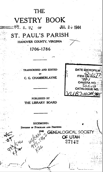
Knowing the lands of Mr. John White helps us to understand more about his life.  However, this is not an easy task since most of the colonial wills and deeds for Hanover and New Kent Counties were unfortunately destroyed during the Civil War.  In order to learn about Mr. John White's lands, it is necessary to scour The Vestry Book of St. Paul's Parish, the principle source of land information for early Hanover and New Kent Counties. Cover of St. Paul's Parish Vestry Minute Book    T he first known procession of lands within St. Paul's Parish occurred in 1708/09.  The vestry divided the parish into smaller sections called precincts, and then ordered that a procession of the property boundaries within each precinct be carried out.  The land owners from a given precinct "walked" the boundary lines together confirming where one person's land ended and another's began.  When the procession was completed, a list of all the property owners within the...

Mr. John White Records 1695 to 1705

Image
1695 to 1705 Record Analysis for John White 1695 Court Order to Maintain Roadways The 1695 New Kent County Court order for Mr. John White is an excellent record.   It provides an honorific name to follow, as well as a specific geographical region within New Kent County.   More importantly, the time span from 1695 (original court order) to 1705 (confirmation of the court order) shows that Mr. John White had an interest in this geographical area for at least ten years.   Figure 1 illustrates an approximate boundary of the court order described area.   The boundary was drawn on an 1867 map of Hanover County r etrieved from the Library of Congress .  Figure 1 A  Represents the mouth of Elder Swamp at Chickahominy River B  Represents the unknown Little Creek, branch of Matadequin Creek C  Represents the approximate area for Pole Green Quarter D  Represents the mouth of Beaverdam Creek at Chickahominy River This geogr...