Mr. John White's Land in St. Paul's Parish (Yellow Community) - Cold Harbor Neighbors James Garrett and Thomas Hooper
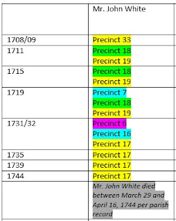
Since we now know the Green Community was located along the Chickahominy River loosely bounded by Beaverdam and Powhite Creeks, we should be able to find the general location of the Yellow Community. If we look at the below table which shows the St. Paul's Parish procession precinct information for Mr. John White's lands, we can see from the precinct numbering pattern from 1711 to 1719, that the Green and Yellow Communities were adjacent or very near to one another. And since there is no known record for how Mr. John White obtained land in the Green Community or a description of the land, the key to narrowing in on a more specific location is the available property information for the other landowners listed in the precinct processions.
Neighboring Land Owners
As mentioned in a previous entry, the early neighboring land owners for Mr. John White's property in the Yellow Community were Thurmond/Thurman, Jerrard/Garrett, Trotman, Woody, Howard, Muirfield, Lindsey, and Barker. The following describes what we know of James Garrett's land. The other early land owners in the Yellow Community will be discussed in upcoming entries.
James Garrett/Jarrartt:

Neighboring Land Owners
As mentioned in a previous entry, the early neighboring land owners for Mr. John White's property in the Yellow Community were Thurmond/Thurman, Jerrard/Garrett, Trotman, Woody, Howard, Muirfield, Lindsey, and Barker. The following describes what we know of James Garrett's land. The other early land owners in the Yellow Community will be discussed in upcoming entries.
The first known record for James Garrett is the St. Peter's Parish baptism record for his son, Joseph, on November 24, 1700. And the first known land record is the 1704 New Kent County, Virginia Quit Rent Roll listing James Garrett as owning 375 acres. How Garrett obtained this land is unknown as a land patent nor deed could be found. This was the same situation for Mr. John White's land in the 1704 Quit Rent list as discussed previously.
The majority of information that we have for James Garrett comes from the St. Paul's Parish Vestry Record. Garrett was listed as a nearby property owner of Mr. John White in 1708/09, 1711, 1719, 1731/32, 1739, and 1744 (the year of Mr. John White's death). The next surviving parish procession record for Garrett in the Yellow Community was in 1751 as shown below.
 This record shows that when the procession was ordered on September 39, 1751, James Garrett still owned his land in the Yellow Community. However, by the time of the return for the 1751 procession, James Garrett had "transferred" his land to Thomas Hooper. Did Garrett sell the land to Hooper or was the transfer the
result of inheritance? Where did James Garrett go if he was still alive? At this time, it is impossible to answer these questions without further
documentation. But we do know that this was the first time Thomas Hooper showed up in the parish procession record. And we know from the Hanover
County, Virginia Chancery Court case Thomas C. Jones & Wife etc vs. Admr. of Joseph Hooper, that upon the land that was transferred from Garrett to Hooper, the home which became known as the Garthright House was built.
This record shows that when the procession was ordered on September 39, 1751, James Garrett still owned his land in the Yellow Community. However, by the time of the return for the 1751 procession, James Garrett had "transferred" his land to Thomas Hooper. Did Garrett sell the land to Hooper or was the transfer the
result of inheritance? Where did James Garrett go if he was still alive? At this time, it is impossible to answer these questions without further
documentation. But we do know that this was the first time Thomas Hooper showed up in the parish procession record. And we know from the Hanover
County, Virginia Chancery Court case Thomas C. Jones & Wife etc vs. Admr. of Joseph Hooper, that upon the land that was transferred from Garrett to Hooper, the home which became known as the Garthright House was built.
The majority of information that we have for James Garrett comes from the St. Paul's Parish Vestry Record. Garrett was listed as a nearby property owner of Mr. John White in 1708/09, 1711, 1719, 1731/32, 1739, and 1744 (the year of Mr. John White's death). The next surviving parish procession record for Garrett in the Yellow Community was in 1751 as shown below.

The Thomas C. Jones & Wife etc vs. Admr. of Joseph Hooper court case, provides a narrative of how "Hooper's Old Place" was passed from the Hoopers, to the Yarbroughs,
and finally to the Garthrights. Today, the
house and land are part of the Cold Harbor Battlefield and Park, all of which are maintained by the National
Park Service. During the civil war
battle at Cold Harbor, Union surgeons used the two-story home as a field
hospital for ten days while members of the Garthright family sought shelter in
the basement of the home. The following
picture was taken just prior to the
National Park Service restoration in 1935.
 |
| Garthright Home in Cold Harbor, Virginia, 1935 Courtesy of the National Parks Service |
The approximate location of the Garthright House is shown on the below map in comparison to the 1695 New Kent County Court Order boundary and approximate location of the Green Community. Knowing where the Garthright House is located provides us with an idea of where Garrett's 375 acres were located. As a result, we have a general idea of where the Yellow Community was located - including Mr. John White's land. And the Garthright House location confirms the possibility that the Yellow and Green Communities were adjacent to or very near one another.
The next entry analyzes Mr. John White's lands located in the Blue Community located on the western branches of Matadequin Creek and Totopotomoi Creek.
 |
| Approximate Location of Green and Yellow Communities in relationship to Garthright House |
copyright@2018 Deborah Thurman Parks


