Between 1715 and 1719, Mr. John White obtained another tract of land in St. Paul's Parish, Hanover County. As with the Yellow and Green Communities, the precinct numbering for this property changed over time. In order to follow this particular piece of land in the St. Paul's Parish processioning record, it has been color coded in the Blue Community.
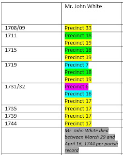 |
| Mr. John White's Lands in St. Paul's Parish Procession Record |
Where was Mr. John White's land in the Blue Community located? Once again, this is a really difficult question to answer as there is no record of how Mr. John White obtained this land. The location of this property can be best determined by researching the lands of the large number of surrounding property owners which included:
John Shelton, Edward and Richard Bullock, John Philips, William, Henry, and John Talley, James Whitlock, Francis and Robert Hester, Widow and Nathaniel Anderson, William Eake, Nicholas Mills, Anthony Hughes, John and Robert Tait, James Durham, John Pond, John Langston, Widow Hickman, Richard Richardson, and John McCoy (McKoy).
John Shelton:
The lands of John Shelton are probably the most well researched of all the landowners mentioned above. Although there is no record of how the Shelton property was obtained, the land and the home built upon it have been well researched due to its historical significance. The Shelton home, known as Rural Plains, is said to have been the location where famous statesman Patrick Henry and Sarah Shelton, daughter of John Shelton, exchanged their vows of marriage.
 |
| Rural Plain courtesy of the Virginia Department of Historic Resources |
 |
| 1864 sketch “At Totopotomoy Creek, Va.” by Alfred R. Waud, courtesy of the National Archives |
Since so much history has occurred on the Shelton property, there are many maps illustrating its location. In the below Civil War Trust map for the Totopotomoy Creek battle, the Shelton property is circled in yellow with Pole Green Church located to the southeast. Pole Green Church (or Pole Green quarter) was mentioned in an earlier post as a boundary marker for Mr. John White's 1695 area of roadway concern.
 |
| Battle of Totopotomoy Creek, courtesy of the Civil War Trust |
The location of John Shelton's property can be compared to Beaverdam Creek and the Garthright House in the below map. The Shelton property, located in the upper center of the map, is shaded green and labeled "Totopotomoy Creek (Rural Plains)". The mouth of Beaverdam Creek at the Chickahominy River is approximately 4 miles south of Rural Plains. And the Garthright House is approximately 6 miles to the southeast.
 |
| Totopotomoy Creek/Rural Plains Vicinity Map courtesy of the National Park Service |
Francis Hester:
A wonderful blog entitled, "Bob's Genealogy Filing Cabinet" has a very informative post on Francis Hester. Bob does an excellent job of explaining that there is no known record of how Francis Hester obtained his land but that Hester appeared to live on the same land, in lower Hanover County near the New Kent County border, for many years. Surnames that obtained land patents in the area of Hester's land (and are also mentioned above as Blue Community surrounding land owners) include White, Bullock, Philips, and Crawford. Based upon these land patents, the Hester land was located south of Totopotomoy Creek, in the vicinity of Matadequin Creek, and among the upper branches of Beaverdam Creek. The Hester land was located somewhere within the black shape on the below map.
 |
| 1862 Map of Hanover County VA - courtesy of the Library of Congress |
Talleys:
As with the Sheltons and Hesters, it is unclear on how the Talley family obtained their lands. But there does appear to have been three distinct Talley mill properties within, or near, the Blue Community. The below snippet of John Wood's 1820 map of Hanover County shows that there were three Talley mills. In 1820, the Talley & Gardner Mill was on a branch of the Totopotomoy Creek. The Parson Talley and Talley Mills were on Matadequin Creek.
 |
| 3 Talley Mills identified on John Wood's 1820 map of Hanover County; courtesy of the Library of Virginia |
The Talley & Gardner Mill may be the location of the 1785 Talley property as described in the below deed, on Stoney Branch of Totopotomoy Creek.
 |
| Hanover County Court, Deeds 1783 - 1792 [31942 Items 2-3] courtesy of the Library of Virginia |
Summary:After researching the land owned by the property owners within the Blue Community, it appears that the community was located adjacent and north of the Green Community. See the below map for the very approximate boundaries for the Green, Yellow, and Blue Communities where Mr. John White owned land in early Hanover County. The following entry analyzes Mr. John White's land that were located in the Purple Community near Grassy Swamp Creek and Stoney Run Creek.
 |
Approximate locations of Green, Yellow, and Blue Communities
copyright@2018 Deborah Thurman Parks
|


